geoexterra
  • Home
  • About Us
    • Vision & Mission
    • Facilities
    • Equipment Rental
    • Photo Gallery
  • Services
    • Geophysical Services
    • Geological Services
    • Hydrogeological Services
    • Hydrological Services
    • Geotechnical Services
    • Satellite & GIS Services
    • Water Conservation
    • Groundwater Recharge
    • Groundwater Extraction
    • Research & Documentation
  • Our Work
    • Ongoing Projects
    • Projects Completed
  • Opportunities
    • Career
    • Partnership
  • Get in Touch
  • More
    • Home
    • About Us
      • Vision & Mission
      • Facilities
      • Equipment Rental
      • Photo Gallery
    • Services
      • Geophysical Services
      • Geological Services
      • Hydrogeological Services
      • Hydrological Services
      • Geotechnical Services
      • Satellite & GIS Services
      • Water Conservation
      • Groundwater Recharge
      • Groundwater Extraction
      • Research & Documentation
    • Our Work
      • Ongoing Projects
      • Projects Completed
    • Opportunities
      • Career
      • Partnership
    • Get in Touch
geoexterra
  • Home
  • About Us
    • Vision & Mission
    • Facilities
    • Equipment Rental
    • Photo Gallery
  • Services
    • Geophysical Services
    • Geological Services
    • Hydrogeological Services
    • Hydrological Services
    • Geotechnical Services
    • Satellite & GIS Services
    • Water Conservation
    • Groundwater Recharge
    • Groundwater Extraction
    • Research & Documentation
  • Our Work
    • Ongoing Projects
    • Projects Completed
  • Opportunities
    • Career
    • Partnership
  • Get in Touch

Hydrological Services

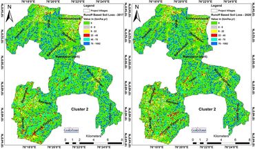
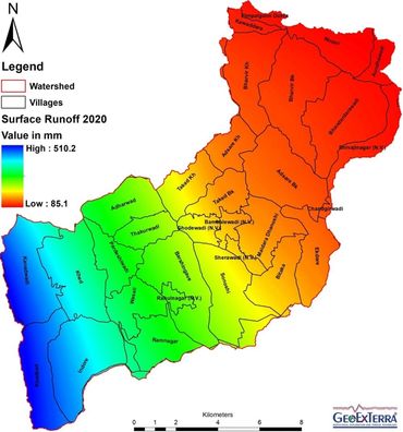
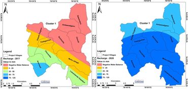
GeoExTerra's® hydrological services encompass a comprehensive suite of advanced methodologies to elucidate the complex dynamics of the hydrological cycle, including: Hydrological cycle modeling: Integration of satellite data, meteorological parameters, river discharge, and soil hydrological characteristics to simulate the precipitation-runoff-infiltration process, enabling accurate estimation of annual water budgets for diverse geo-climatic terrains. Water balance analysis: Quantification of surface runoff, surface storage, evapotranspiration, and infiltration to understand the recharge-discharge relationship, influencing groundwater table and river/stream flow. River/stream runoff gauging and monitoring: Installation of hydrometric stations to measure river discharge, stage, and velocity, facilitating real-time monitoring of hydrological processes. Sediment yield modeling: Application of advanced numerical models to simulate sediment transport, erosion, and deposition, informing soil conservation strategies and reservoir management. Hydrological soil mapping: Characterization of soils and their hydrological properties, including infiltration capacity, hydraulic conductivity, and water retention, to develop high-resolution hydrological maps. Advanced hydrological modeling: Development of distributed hydrological models, incorporating GIS and remote sensing data, to simulate hydrological processes, predict flood events, and optimize water resources management. Water conservation planning: Design and planning of water harvesting structures, soil conservation measures, and crop planning strategies to enhance soil moisture, control baseflow, and mitigate soil loss. By harnessing cutting-edge technologies and methodologies, GeoExTerra provides high-precision hydrological services, enabling informed decision-making and sustainable management of water resources.

Hydrological Modeling & Analysis

 - Hydrological water balance modeling: Quantification of annual water budgets for diverse spatial scales (basin, sub-basin, watershed, micro-watershed) incorporating precipitation, runoff, infiltration, evapotranspiration, and groundwater recharge.

 - River/stream hydrometry: Installation and operation of gauging stations to measure river discharge, stage, and velocity, facilitating real-time monitoring of hydrological processes.

 - Surface hydrology and unit hydrograph analysis: Characterization of surface runoff processes, including rainfall-runoff relationships, to develop unit hydrographs for predicting storm responses.

 - Distributed hydrological modeling: Development of physically-based models, incorporating GIS and remote sensing data, to simulate hydrological processes, including runoff, infiltration, recharge, baseflow, surface storage, and evapotranspiration.

 - Sediment yield and transport modeling: Application of numerical models to simulate sediment erosion, transport, and deposition, informing soil conservation strategies and reservoir management.

 - Surplus runoff utilization planning: Identification of opportunities for water harvesting and conservation structure planning to optimize utilization of non-committed surplus runoff.

 - Baseflow assessment and enhancement: Identification of areas for baseflow retardation and enhancement strategies to support ecological and agricultural development.

 - Groundwater recharge and budgeting: Estimation of annual groundwater recharge, availability, and budgeting to inform sustainable groundwater management.

 - Flood warning and riverfront development: Development of flood early warning systems and riverfront development planning to ensure safety of reservoirs, bridges, and surrounding infrastructure.

  • Privacy Policy
  • Terms and Conditions

GEOEXTERRA®

Office (Registered) S8, 2nd Floor, Pankaj Central Plaza, Plot No. 5, Sector 12, Dwarka, New Delhi - 110 078, Delhi, India Office (Business) E 137, Balaji Bhavan, West Vinod Nagar, New Delhi - 110 092, Delhi, India

Email: info@geoexterra.com Phone: +91 8400662626

Copyright © 2018 GeoExTerra® Geophysical Exploration and Terrain Technology Private Limited - All Rights Reserved.