geoexterra
  • Home
  • About Us
    • Vision & Mission
    • Facilities
    • Equipment Rental
    • Photo Gallery
  • Services
    • Geophysical Services
    • Geological Services
    • Hydrogeological Services
    • Hydrological Services
    • Geotechnical Services
    • Satellite & GIS Services
    • Water Conservation
    • Groundwater Recharge
    • Groundwater Extraction
    • Research & Documentation
  • Our Work
    • Ongoing Projects
    • Projects Completed
  • Opportunities
    • Career
    • Partnership
  • Get in Touch
  • More
    • Home
    • About Us
      • Vision & Mission
      • Facilities
      • Equipment Rental
      • Photo Gallery
    • Services
      • Geophysical Services
      • Geological Services
      • Hydrogeological Services
      • Hydrological Services
      • Geotechnical Services
      • Satellite & GIS Services
      • Water Conservation
      • Groundwater Recharge
      • Groundwater Extraction
      • Research & Documentation
    • Our Work
      • Ongoing Projects
      • Projects Completed
    • Opportunities
      • Career
      • Partnership
    • Get in Touch
geoexterra
  • Home
  • About Us
    • Vision & Mission
    • Facilities
    • Equipment Rental
    • Photo Gallery
  • Services
    • Geophysical Services
    • Geological Services
    • Hydrogeological Services
    • Hydrological Services
    • Geotechnical Services
    • Satellite & GIS Services
    • Water Conservation
    • Groundwater Recharge
    • Groundwater Extraction
    • Research & Documentation
  • Our Work
    • Ongoing Projects
    • Projects Completed
  • Opportunities
    • Career
    • Partnership
  • Get in Touch

Geophysical Services

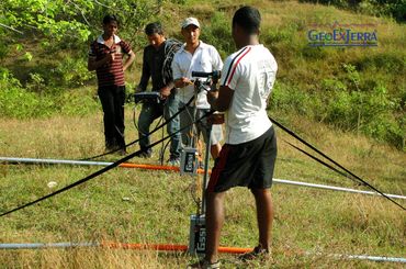
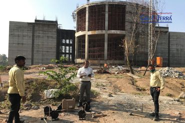
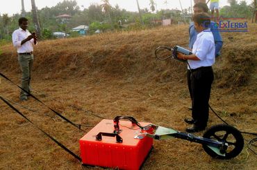
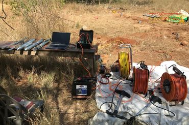
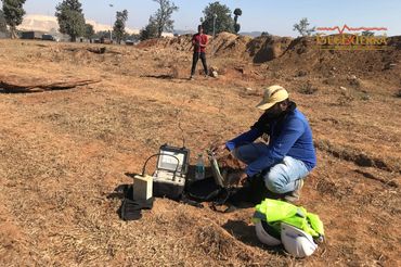
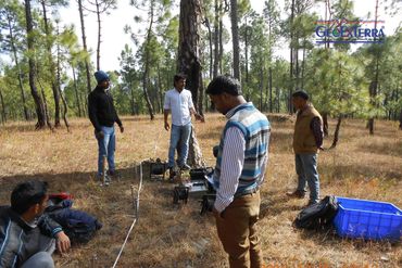
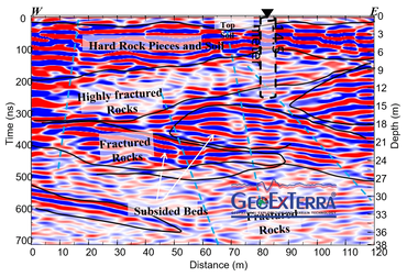
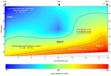
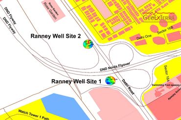
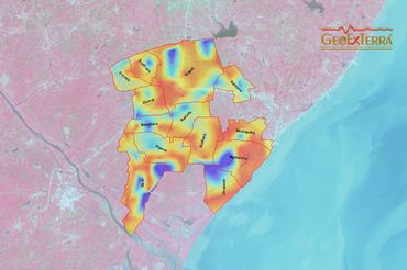
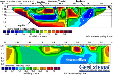
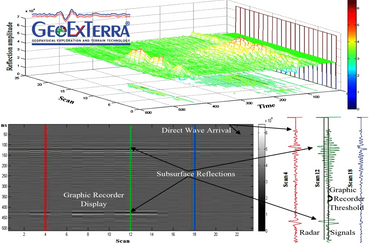
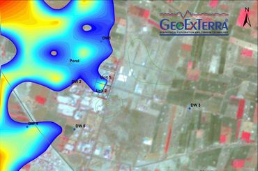
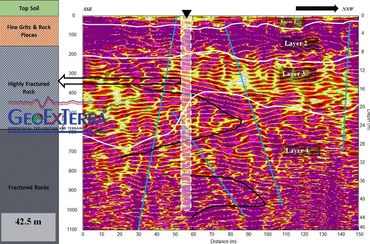
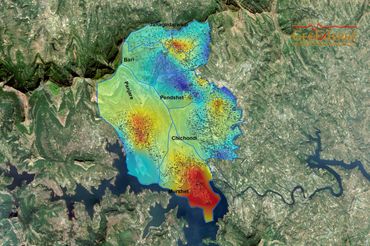
GeoExTerra® specializes in the application of cutting-edge geophysical methodologies to elucidate the Earth's subsurface structure and identify potential resource targets, including groundwater, hydrocarbons, and minerals, across complex geological terrains. Our expertise encompasses: Electrical techniques: 2D/3D electrical resistivity tomography (ERT), induced polarization (IP), spontaneous potential (SP), and electrical sounding (ES) for subsurface imaging and characterization. Seismic methods: high-resolution seismic tomography for velocity modeling, elastic moduli, and structural analysis. Magnetic and electromagnetic techniques: proton magnetic resonance (PMR), magnetotellurics (MT), ground-penetrating radar (GPR), transient electromagnetics (TEM), and very low frequency (VLF) for subsurface mapping and target identification. Geophysical well logging: advanced logging services, including electrical, optical imaging, for in-situ characterization of subsurface formations. Our services enable the acquisition and processing of high-fidelity geophysical data, facilitating informed decision-making in mineralogical, hydrogeological, hydrocarbon, archaeological, geoengineering, geological, and mining applications.

GEOPHYSICAL INVESTIGATION

- Mining exploration: high-resolution imaging of economically viable earth minerals via advanced geophysical techniques.

- Hydrocarbon exploration: integrated geophysical surveys for subsurface hydrocarbon detection and mapping.

- Seismic refraction tomography (SRT) and MASW : high-fidelity imaging of subsurface velocity, elastic moduli, structures for lithological and structural analysis.

- Seismic well logging: advanced downhole, crosshole, and P-S logging for elastic moduli and in-situ characterization of subsurface formations.

- Geotechnical investigation: comprehensive analysis of soil and rock properties for infrastructure development (dams, foundations, tunnels, underground powerhouses, storage facilities).

- Subsurface fracture, conduit, and cavity detection: high-resolution imaging of shallow and deep subsurface features via advanced geophysical techniques.

- Aquifer mapping and groundwater investigation: integrated geophysical and hydrogeological surveys for subsurface water resource characterization.

- Geophysical well logging: advanced electrical, optical imaging, and coring services for in-situ subsurface formation evaluation.

- Groundwater recharge and abstraction site zonation: geophysically-informed delineation of optimal recharge and abstraction zones.

- Industrial pollutant plume investigation: high-resolution imaging of subsurface contaminant distributions.

- Seawater intrusion investigation: geophysical monitoring of coastal aquifer salinization.

- Archeological investigation and buried object detection: non-invasive geophysical surveys for cultural heritage preservation and buried feature location.

Geophysical Data Modelling

- Error correction via robust statistical methodologies, mitigating artefacts and ensuring data fidelity.

- Advanced geophysical data processing and inversion techniques, leveraging regularization methods and inverse theory for accurate subsurface characterization.

- Transform-based analysis, utilizing Fourier, Radon, and Wavelet transforms to extract salient features and facilitate dimensionality reduction.

- Least-squares data modeling, invoking one-sided functions and singular value decomposition (SVD) for robust parameter estimation and model calibration.

- Multichannel time series analysis, employing matrix factorization and eigendecomposition to elucidate subsurface dynamics and identify coherent signals.

- Spatiotemporal subsurface dynamics characterization, integrating seismic, electromagnetic, and gravity data to constrain models and elucidate complex subsurface processes.

- Seismic data processing via wave equation-based methods, including finite-difference, finite-element, and spectral-element techniques for accurate wavefield simulations.

- Parameter estimation of geophysical objects, utilizing Bayesian inference, Markov chain Monte Carlo (MCMC), and machine learning algorithms for robust uncertainty quantification.

- Geophysical data integration, combining disparate datasets via joint inversion and fusion techniques to enhance subsurface resolution and reduce ambiguity.

- Constrained and time-lapse inversion, incorporating regularization techniques (L1, L2, Cauchy) and 4D inversion to monitor subsurface changes and optimize model updates.

  • Privacy Policy
  • Terms and Conditions

GEOEXTERRA®

Office (Registered) S8, 2nd Floor, Pankaj Central Plaza, Plot No. 5, Sector 12, Dwarka, New Delhi - 110 078, Delhi, India Office (Business) E 137, Balaji Bhavan, West Vinod Nagar, New Delhi - 110 092, Delhi, India

Email: info@geoexterra.com Phone: +91 8400662626

Copyright © 2018 GeoExTerra® Geophysical Exploration and Terrain Technology Private Limited - All Rights Reserved.